


YES24 카테고리 리스트
YES24 유틸메뉴
- Global YES24안내보기
-
Global YES24는?
K-POP/K-Drama 관련상품(음반,도서,DVD)을
영문/중문 으로 이용하실 수 있습니다.Korean wave shopping mall, sell the
English
K-POP/K-Drama (CD,DVD,Blu-ray,Book) We aceept PayPal/UnionPay/Alipay
and support English/Chinese Language service作为出售正规 K-POP/K-Drama 相关(CD,图书,DVD) 韩流商品的网站, 支持 中文/英文 等海外结账方式
中文Exclusive ticket sales for domestic and international pop artists
Global yesticket
어깨배너

.jpg)


외국도서 카테고리리스트
- ELT 사전
- 문학 소설
- 경제 경영
- 인문 사회
- 예술 대중문화
- 취미 라이프스타일
- 컴퓨터
- 자연과학
- 대학교재 전문서
- 해외잡지
- 유아 어린이 청소년
- 캐릭터북
-
초등코스북
- [All Aboard]
- [Amaze!]
- [American Start with English]
- [Backpack]
- [Beeline Plus]
- [Best Friends]
- [Bounce]
- [CANDO]
- [Catch!]
- [Domino]
- [English Land]
- [English Time]
- [Express Ways]
- [Give Me Five!]
- [Gogo Loves English]
- [High Five]
- [Hip Hip Hooray]
- [Know It All!]
- [Let's Go]
- [New Parade]
- [New Super Kids]
- [Open House]
- [Password English]
- [Pingu Loves English]
- [Pockets]
- [Popcorn]
- [Primary Colors]
- [S.F.ESL]
- [Side by Side]
- [Smile]
- [Star Team]
- [Super Kids]
- [Up and Away in English]
- [We Can!]
- [Welcome to America]
- [Wise Brain]
-
학습서
- <학습서 새 책>
- 학 습 서
- [Grammar & Spelling 문법]
- [Phonics 파닉스]
- [Song & Chant 챈트]
- [Vocabulary 어휘]
- Early Reader 읽기:초급
- Reader 읽기:중급 이상
- [Reading & Comprehension 독해]
- [Math 수학]
- [Science 과학]
- [Junior Academic 주니어아카데믹]
- [Master Skills 마스터스킬]
- [SMART Reading & SMART Listening]
- [Spectrum 스펙트럼]
- [SRA Skills Handbook SRA스킬핸드북]
- [Brain Quest]
- [Core Skills: Language Arts]
- [Exerpriences with Writing Styles]
- [Fingerprints]
- [Introduction to Journal Writing]
- [Let's Go LeapPad 립패드]
- [Other Subjects 역사/지리]
- [Social Studies 사회]
- [Spark Notes]
- [Speaking & Listening 말하기 & 듣기]
- [Spotlight on Literacy]
- [Steck-Vaughn Critical Thinking]
- [Steck-Vaughn Language Exercises]
- [Steck-Vaughn Language Handbooks]
- [Steck-Vaughn Spelling Linking Words to Meaning]
- [Steck-Vaughn Think-Alongs]
- [Wordly Wise 3000]
- [Writing 쓰기]
- 영유아
- 일본도서
- 중국도서/기타 아시아 도서
- 프랑스도서
- Lexile®
-
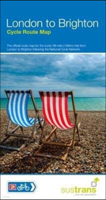
수입| Cordee | 2017년 06월18,220원 (18% 할인) 포인트적립 920원상품 판매가 시작되면 알려드립니다. 판매시작 알림 서비스란? 신청하기The official map for the iconic 68-mile (109km) ride. National Route 21 from London to Crawley. National Route 20 from Crawley to Brighton.
-
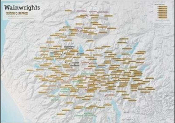
수입| Cordee | 2017년 05월29,160원 (18% 할인) 포인트적립 1,460원Scratch Off Wainwright Hill-bagging Print is the perfect gift for walkers / hill climbers or lovers of the Lake District.
-
수입| Land & Property Services | 2017년 01월20,040원 (18% 할인) 포인트적립 1,010원The Annandale Way is a splendid walk in a little-known but accessible part of southern Scotland. It starts in Moffat and runs for 56 miles (90 km) via Lochmaben to reach the Solway Firth at Newbiebarns. A shorter branch goes via Lockerbie and Eskrigg Nature Reserve. There are superb views, wildlife ...
-
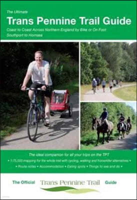
수입The Ultimate Trans Pennine Trail Guide Coast to Coast Across Northern England by Bike or on Foot [ Paperback ]Thorne Jenny | Excellent Books | 2017년 01월18,140원 (18% 할인) 포인트적립 910원An entirely new guide to the Trans Pennine Trail. The hugely popular 370 miles (595km) of trail across the north of England is a big favourite with walkers and cyclists. The trail is suitable for users of all ages and abilities due to its easy gradients and traffic free conditions.
-
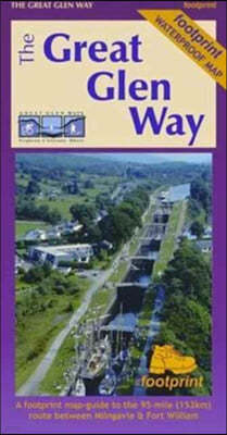
수입Footprint Maps | Footprint Maps | 2017년 02월19,970원 (18% 할인) 포인트적립 1,000원A Footprint map-guide to the 95 mile (153km) route between Milngavie & Fort William. A 1:40,000 scale map based on OS data, printed on waterproof paper with compact and concise information for walkers.
-
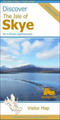
수입| Cordee | 2017년 02월18,140원 (18% 할인) 포인트적립 910원Visitor map of The Isle of Skye - based on OS data with loads of additional information. 1:110,000. In the Discover series from Footprint maps. Printed on waterproof paper. Includes Raasay, Rona, Scalpay and Soay.
-
수입| Ordnance Survey | 2017년 07월23,690원 (18% 할인) 포인트적립 1,190원상품 판매가 시작되면 알려드립니다. 판매시작 알림 서비스란? 신청하기This customised map, featuring routes for all three peaks, will support you in your adventure and can be used for planningand navigating during your challenge. Cover photo of Snowdon.
-
수입| Harper Collins Cartographic | 2017년 12월9,100원 (18% 할인) 포인트적립 460원New edition of annually revised, politically coloured road map of France at 18 miles to 1 inch / 11km to 1cm (1:1,120,000). The map shows individual department by name, and cities, towns, roads, European route numbers, motorways and toll motorways are clearly shown, making it the ideal map for plann...
-
수입| Harper Collins Cartographic | 2017년 12월9,100원 (18% 할인) 포인트적립 460원Annually revised, politically coloured road map of Europe at a scale of 79 miles to 1 inch / 50km to 1cm (1: 5,000,000). Roads, motorways, European Route numbers, railways, airports, cities and towns are clearly shown, making the map ideal for route-finding and planning.
-
수입| Harper Collins Cartographic | 2017년 12월23,690원 (18% 할인) 포인트적립 1,190원Up-to-date A4 spiral bound road atlas of Europe. Contains clear, detailed road mapping, perfect for touring the Mediterranean, Iberian peninsula, Scandinavia and many other European tourist destinations.
-
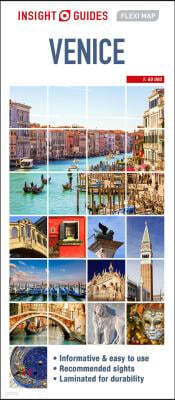
수입Insight Guides (COR) | Insight Guides | 2017년 12월13,610원 (18% 할인) 포인트적립 690원Flexi map Venice is laminated, durable and has its own index that has been categorised for ease of use.
-
수입Insight Guides | APA Publications | 2017년 12월13,610원 (18% 할인) 포인트적립 690원Flexi Map Algarve is much more than just a laminated map. The tourist information section includes detailed descriptions and some stunning photographs of a carefully selected number of recommended sights, these sights are linked to the mapping by easy to find numbered markers.
-
수입Not Available (NA) | Harpercollins Pub Ltd | 2005년 02월24,150원 (10% 할인) 포인트적립 1,210원An extended and rebranded edition of the "Collins Longman Foundation Atlas", designed for Key Stage 4 students to support and motivate them in geographical and mapping skills.
-
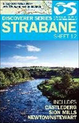
수입| Land & Property Services | 2017년 01월16,400원 (18% 할인) 포인트적립 820원The Discoverer series are designed for tourist and leisure activities. Each one covers an area of 40km x 30km at the scale 1:50,000. There are 93 sheet in the series. 75 are produced by Ordnance Survey Ireland and 18 by Ordnance Survey Northern Ireland.
-
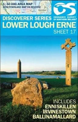
수입| Land & Property Services | 2015년 01월20,040원 (18% 할인) 포인트적립 1,010원The Discoverer series are designed for tourist and leisure activities. Each one covers an area of 40km x 30km at the scale 1:50,000. There are 93 sheet in the series. 75 are produced by Ordnance Survey Ireland and 18 by Ordnance Survey Northern Ireland.
-
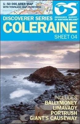
수입| Land & Property Services | 2016년 01월20,040원 (18% 할인) 포인트적립 1,010원The Discoverer series are designed for tourist and leisure activities. Each one covers an area of 40km x 30km at the scale 1:50,000. There are 93 sheet in the series. 75 are produced by Ordnance Survey Ireland and 18 by Ordnance Survey Northern Ireland.
-
수입| Land & Property Services | 2016년 01월16,400원 (18% 할인) 포인트적립 820원1: 25,000 scale Causeway Coast and Rathlin Island Activity Map - printed on water resistant paper - includes waymarked walks, surfing beaches, canoe trail access points, Giants Causeway World Heritage Site, Northwest 200 Motorcycle Road Race Route, and Rathlin Island.
-
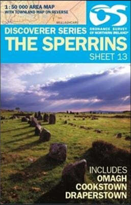
수입| Land & Property Services | 2015년 01월20,040원 (18% 할인) 포인트적립 1,010원The Discoverer series are designed for tourist and leisure activities. Each one covers an area of 40km x 30km at the scale 1:50,000. There are 93 sheet in the series. 75 are produced by Ordnance Survey Ireland and 18 by Ordnance Survey Northern Ireland.
-
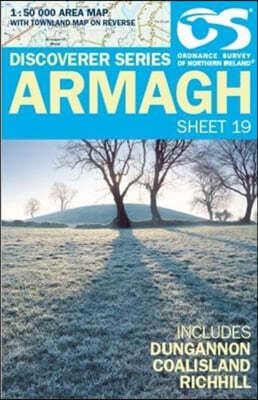
수입| Land & Property Services | 2012년 01월20,040원 (18% 할인) 포인트적립 1,010원The Discoverer series are designed for tourist and leisure activities. Each one covers an area of 40km x 30km at the scale 1:50,000. There are 93 sheet in the series. 75 are produced by Ordnance Survey Ireland and 18 by Ordnance Survey Northern Ireland.
-
수입Philip's Gift Edition Street Atlas London - new hardback edition De Luxe Edition Union Jack [ Hardback ]| Philip's | 2017년 09월16,400원 (18% 할인) 포인트적립 820원A new Philip's De Luxe edition of this detailed colour mini street atlas, covering all of London from Richmond to Greenwich and from Highgate to Streatham, with enlarged maps of central London from Earl's Court to Tower Bridge.


- 예스이십사(주)
-
대표 : 김석환, 최세라
주소 : 서울시 영등포구 은행로 11, 5층~6층(여의도동,일신빌딩)
사업자등록번호 : 229-81-37000 통신판매업신고 : 제 2005-02682호 사업자 정보확인
이메일 : yes24help@yes24.com 호스팅 서비스사업자 : 예스이십사(주)
Copyright ⓒ YES24 Corp. All Rights Reserved.

- 소비자피해보상보험 서울보증보험
- 고객님은 안전거래를 위해 현금 등으로 결제 시 저희 쇼핑몰에서 가입한 구매안전서비스를 이용하실 수 있습니다. 서비스가입사실 확인